

If you’ve ever had what you thought was going to be a “perfect camping trip” ruined by an unexpected late night downpour or cold front, you’ve probably realized the importance of a good weather forecast when planning an overnight outing. Not all weather forecasts are created equal, with most being tailored to the needs of city dwellers, who may only need the most basic information – such as how to dress the kids for school the next morning. Those who’re setting out to pursue outdoor adventures, including camping and hiking, need more than just a basic weather forecast.
In this post we’ll go over some of the best camping weather apps and websites, along with some devices that can receive weather forecasts without cellular coverage.

Caught by Storms While Off-Road in New Mexico
Last summer we decided to spend a couple days exploring BLM land near Taos, where we’d ventured about 30 miles off the pavement into the desert. The dirt track wasn’t difficult by any means, and we had plenty of supplies for a multi-day trip. What we hadn’t planned on was the early arrival of the monsoon season, which wasn’t mentioned in the weather forecast we’d read online.
As the storm clouds began to roll in and rain turned dry arroyos into swiftly running streams in a matter of minutes, we couldn’t do anything but find higher ground and wait for the water to subside, then make our exit before the next wave of thunderstorms rolled in. It was a muddy slog, in four wheel drive low, back to the highway, that could have been avoided with a better weather forecast.
Using Aviation Weather For Planning a Camping Trip
Weather forecasts designed to be used by pilots for route planning are far more detailed than those found the evening news, or sites like Weather.com. For the crucial weather forecasts it relies on, the aviation industry uses METAR (Meteorological Aerodrome Reports), which are reported from airport weather stations. METAR is displayed in a long string of codes, such as this one: METAR LBBG 041600Z 12012MPS 090V150 1400 R04/P1500N R22/P1500U +SN BKN022 OVC050 M04/M07 Q1020 NOSIG 8849//91=
This data can tell a pilot everything from wind direction and weather trends, to whether there is snow on the runway or not. Most of us don’t “speak METAR”, which is why we like using a visual display of this info for the airport nearest where we’re planning a trip. Visual interpretations of METAR weather forecasts can be found on Air Sports Net Weather, and these are very useful for seeing exactly what kind of conditions you can expect over a 24 hour period. Unfortunately Air Sports Net doesn’t yet have an app yet and forecasts are only available on their website.
Why Aviation Weather Forecasts Are So Useful For Camping
Knowing details such as which way prevailing winds are likely be blowing in the middle of the night, or at what hour thunderstorms are expected, can help you to better set up camp so that you and your gear are better protected from the elements. One look at the chart below can tell you which direction might be best to orient your tent so that you could enjoy a nice breeze during the afternoon, but not have cold wind in your face at 2:00 AM.
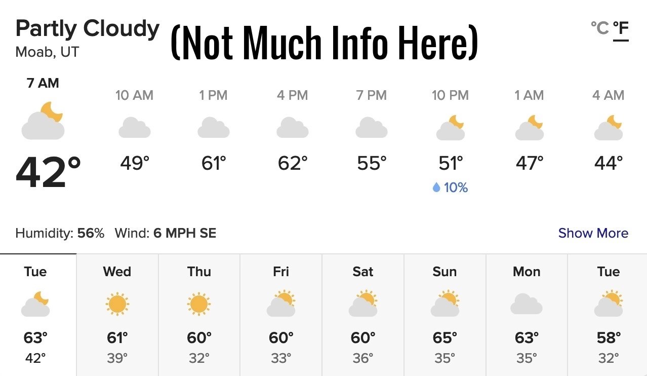
A Comparison of Hourly Forecasts
vs.
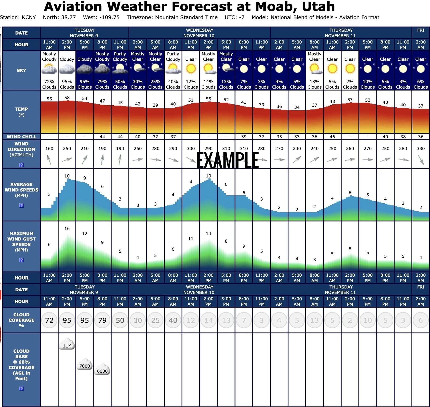
 As you can see, there’s much more information in an aviation weather forecast, although not all of it may be relevant to your outdoor planning. What makes these so useful is that you’re able to see temperature, wind direction and rain chances and more, on an hourly basis, throughout a 24 hour period.
You may want to give these handy forecasts from Air Sports Net a try before planning your next camping trip, and granted, they are only for designated airports, you can often find a forecast that’s close enough to the area you’re planning on recreating in.
NOAA Weather Radio – A Very Useful Tool For Campers
You may not have a cellular connection where you’re camping, and that’s why NOAA weather radios are so useful. The National Oceanic and Atmospheric Administration (NOAA) operates a network of weather-only radio stations across the US. These broadcast emergency weather alerts, along with local conditions and forecasts. You can’t receive these broadcasts on a standard AM-FM radio – only on a special “weather radio” capable of receiving NOAA broadcasts.

Portable Weather Radios Capable of S.A.M.E.
Some NOAA weather radios are able to remain in sleep mode and be activated by S.A.M.E (Specific Area Message Encoding), to alert you of severe weather your area. Most radios capable of S.A.M.E are made for home use, but there is one made by Midland that’s battery operated and made for the outdoors, the Midland HH54VP.
If you have a GMRS two-way radio. such as the BTECH GMRS-50X1, that’s capable of receiving VHF frequencies, you can program these 7 NOAA channels and monitor them every so often on your trip. Unfortunately NOAA stations can sometimes be hard to pick up in very remote areas, yet we’re often surprised by just how good their coverage is, especially if you’re up at high elevations. A list of NOAA weather stations can be found here, along with info on how the S.A.M.E and All Hazards alert systems function.
NOAA Weather Frequencies
|
162.400
|
162.425
|
162.450
|
162.475
|
162.500
|
162.525
|
162.550
|
Best Weather Apps For Camping
If you are lucky enough to have a cellular connection in the great outdoors, there are a couple of weather apps that are very useful for campers and hikers.
- Weather Underground – Weather Underground is a free app that’s available for iOS and Android. It features everything from local radar and the location of frontal boundaries, to 24 hour precipitation forecasts sunset times, current moon phase and a daily planning forecast. A premium version is available for $3.99/mo, and features even more detailed local info.
- Dark Sky Weather – This weather app is very useful for camping and outdoor pursuits where you need to know exactly what’s about to go down at your location. Advertised as a “hyperlocal weather app”, you can get very detailed forecasts for your exact location. According to the developer “Dark Sky uses NOAA and TDWR radar, supplemented by proprietary algorithms to produce their hyper-local forecasts.” We’ve used this weather app on a friend’s iPhone and absolutely love it. Unfortunately it’s not available yet for Android, but hopefully that’ll change. (There is an app with the same name on Google Play, but it’s not the same product.)
Garmin InReach Weather
If you own a Garmin InReach satellite messenger, you can get custom weather forecasts for your exact location, even without cell phone service. Garmin weather forecasts are available in basic, detailed and marine forecasts. There is a charge for each of these, so check the fine print before ordering. To order a weather forecast from most InReach devices follow these steps:
Related Articles:
How To Monitor USFS Frequencies
The author, Troy H., has been involved in radio technology since the 1980’s and holds both amateur advanced class and GMRS radio licenses.
*This article may feature affiliate links. There is no added fee if our readers use them.


